Yunnan Tea and Horse Road
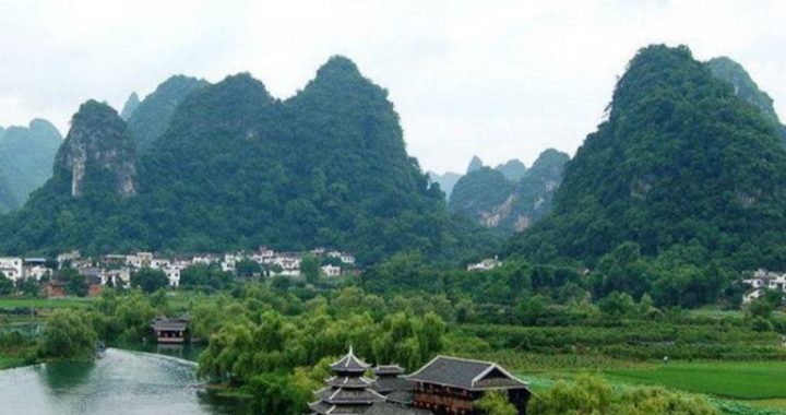
11 min readlong with yaks and Buddhism, tea is a defining feature of Tibetan Aculture, yet the beverage is brewed with leaves of a subtropical shrub that cannot be grown in Tibet’s harsh alpine environment. Just south of Tibet, however, southern Yunnan produces some of the best teas in the world. Lying between these two realms is northwest Yunnan, with its three great river valleys perfectly aligned north-south as natural conduits for trade.
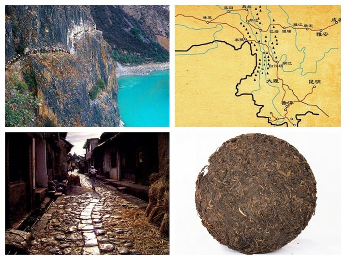
Indeed, one of East Asias great caravan routes crossed this area, known in English as the Yunnan Tea and Horse Road. The formal Chinese name isthe “Ancient Road of Tea and Horses between Yunnan and Tibet,”which indicates its great age, primary trading partners, and the two main items of trade along the route.
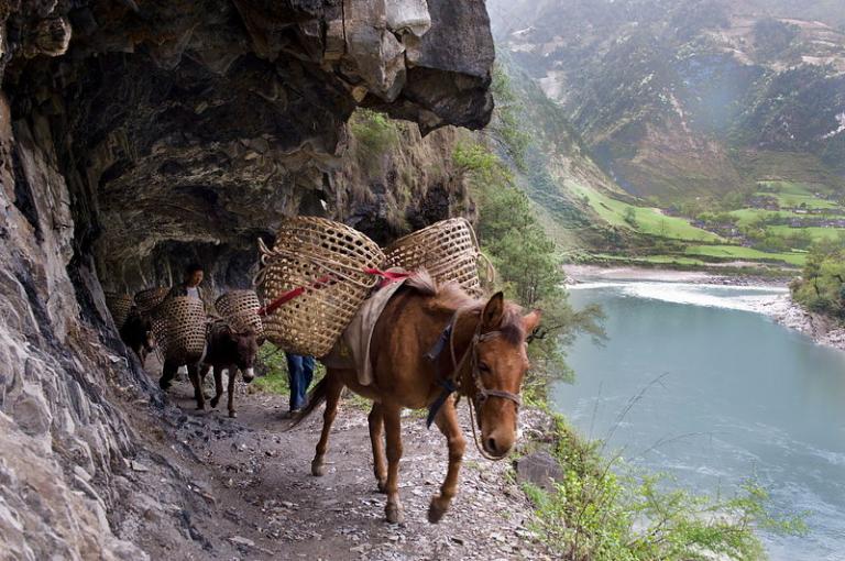
The term Tea and Horse Road is somewhat misleading. Similar to the Great Wall and Silk Road, which consisted of many walls and many roads, the Yunnan Tea and Horse Road actually comprised several major routes across the rugged Yunnan terrain. For the most part, these paths followed thebig rivers. Quite frequently, however, the trails encountered steep topography that required travelers to negotiate the high divides between valleys. The westerly direction of trade toward Tibet’s capital, Lhasa, also pulled caravans out of the relative warmth of the deep valleys across the cold mountain passes.
The three main exports from Yunnan in ancient times were silver, tea, and horses. Silver was mostly sent to eastern China, but tea and horses were transported widely, including to Tibet through northwest Yunnan. The historical connection between Tibet and Yunnan started before Tibetans began to drink tea in the 8th century. By the 13th century, yak butter tea,aconcoction of tea, yak butter and a pinch of salt, had reached near universal status in Tibet, such that the caravan roads through northwest Yunnan became a major trade route. During the Ming and Qing Dynasties(1368-1911), the Tibetan demand for tea was totally dependent on Yunnan and Sichuan provinces.
The horse trade is less well known today because horses are no longer traded in large quantities, but at one time, Yunnan horses were a famous local product. Marco Polo traveled through Yunnan in the 13th century and remarked,”The best horses(in China) are bred in this province.”Breedsdeveloped in Yunnan were smaller than the grassland horses of the north, but were well adapted to rugged, mountainous terrain and widely traded for centuries throughout South and East Asia.
While important for trade, the Yunnan Tea and Horse Road was not considered militarily strategic by Qing rulers(1644-1911), at least compared to the tea road through Sichuan. There was only a nominal government and military presence along the route. Apparently, however, it was enough to keep banditry at bay. During the first half of the 20th century, as the Qing Dynasty failed and was followed by a similarly weak Nationalist government, bandit troubles increased, causing considerably reduced trade along theroute. Goods from southern Yunnan were sent across trouble-free British Burma to India instead, then north into Tibet.
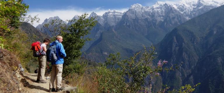
This was the situation that Westerners encountered as they began entering northwest Yunnan in the 1840s via the timeworn trade routes. At first in writings and drawings, and later with photography, they spent considerable energy documenting the modes of transportation and the manner of its infrastructure. It was only the most adventurous explorers, collectors, and missionaries that occasionally strayed from these major routes and traveled on the lesser-used, local trail network. This factor was of great benefit to me in relocating old photo points, helping expedite the rephotography process greatly.
Attempts to expand the first vehicle roads into northwest Yunnan, north of Dali, started in the late 1930s. It was nearly 20 years later, however, before road building started in earnest. The first major highway to the Tibetan Plateau was built in 1959 on an alignment from Dali to Weixi to Deqin, following the main caravan route. The alignment was later moved to Zhongdian(now Shangri-La) instead of Weixi. For this reason, there are many more old photographs of Weixi, now off the beaten path, than thereare of Zhongdian, now on the major trade and tourist route. For decades these roads were slow dirt tracks through the mountains and canyons of Yunnan. As slow and arduous as they were, however, they provided new access to markets and services in Zhongdian, Weixi, Lijiang, and beyond for hundreds of remote towns and villages.
Route conditions remained the same until the early 2000s when central government funding was directed to infrastructure development in western China. This financial support is part of the generation-long Western Development Initiative, the goal of which was to bring parity between economic conditions in western China during the next 30 years and what had occurred in eastern China during the past 30. The ancient Yunnan Tea and Horse Road was transformed from a caravan route into a modern road system in just 50 years. As often happens in China, however, this sort of investment tends to come in spurts. Hence the old Chinese proverb”A road is good for ten years and bad for ten thousand.”My prediction is that the proverb will remain relevant for a long time.
Five kilometers (3 miles) upriver from Shigu town, an important stage stop along the caravan route, the mountains descend steeply to the river’s edge at a place known as the Stone Gate. Joseph Rock traveled along this route in the early fall, apparently after the monsoonal river surges of summer had subsided. Rock reported that, during summer high water, this paved section of the Tea and Hose Road was often underwater.
This route was one of the first in northwestern Yunnan to be upgraded for motor vehicle traffic in 1959. For most of its existence the motor road had a rough gravel surface. The segment shown here was upgraded with asphalt pavement during the winter of 2001-2002, primarily to speed tourists to the Liming Scenic Area of Laojun Mountain. Road construction required major blasting of the cliffs to ensure flooding wouldn’t hinder travel. The modern photograph was taken a few months after the road was upgraded and paved and shows the results of recent construction activity.
Like many travelers before him,C.. FitzGerald followed the Tea and Horse Road toward Tibet in 1938. Seven kilometers (4.3 miles) up the Jinsha River above Stone Gate he encountered another big cliff next to the river, this one named Red Rock after the orange-yellow tinge on some of the rock face. We could not occupy FitzGerald’s original photo point due to road construction, so the perspective is slightly different. FitzGerald did not identify the building nestled into a hollow between the river and cliff. It could have been a temple, but no trace is left today.
Twenty-five kilometers (15.5 miles) north of the previous photo point, the Liming River enters the Jinsha River near the town of Balo. At that confluence, FitzGerald photographed this suspension bridge over the Liming River, which he labeled “iron chain bridge”on his photograph. Although it is a relatively short bridge, the large abutments testify to its importance as a link on the Tea and Horse Road. The Liming River is prone to flash flooding because of the large area of exposed sandstone at its headwaters. Large, well-constructed abutments were needed to prevent the bridge from washing away. Now the same recently paved river road seen in previous photos crosses a similarly well-constructed Zhongxin Bridge.
The main route of the Yunnan Tea and Horse Road leaves the Jinsha River and turns west over the mountainous divide toward the Lancang River.
From the divide it descends to the town of Weixi, then, as now,a regional economic and government center and major stage stop on the old caravan route. Twenty-five kilometers (15.5 miles) downstream from Weixi, the Yongchun River enters this small gorge just above its confluence with the Lancang River. This sight must have been impressive to travelers of the day.
In addition to Joseph Rock in 1923, Frank Kingdon-Ward photographed almost the same scene in 1911, followed by J.W. Gregory in 1922.
Rock and the others took their photos from the trail on the north side of the Yongchun River, looking down-canyon to the west. The road, originally constructed in 1959, was built on the south side of the river. It was being paved with asphalt during the winter of 2003-2004 when we took this photo, and a camp for construction workers is seen occupying the river terrace where corn was raised in 1923. The old trail, seen traversing the base of the cliff in the center-right, is still used by Han and Lisu farmers north of the river to gain road access.
Continuing 100 kilometers(62 miles) up the Lancang River from the mouth of the Yongchun River, the Yunnan Tea and Horse Road can be seen as a major trail on the east side of the river in 1923. The modern vehicle road faithfully follows the old caravan route. It has been paved since this photo was taken in 2003.
Large cypress trees (Cupressus duclouxiana) line the west bank of the river in both the old and modern scenes, an unusual sight in the Lancang valley.
Also of note in both images is the thick horizontal line of green shrubs that traverses the arid canyonside in the center of the scene. These tall shrubs line an irrigation canal that delivers water from a small tributary to the village of Chalitong, upriver just around the corner.
As we will see in the next three sets of photographs, crossing the great rivers of northwest Yunnan presented special problems for early travelers.
In 1923, Joseph Rock had to use a ferry to cross the Jinsha River near the village of Jinhong. He was crossing the river on an expedition through Tiger Leaping Gorge in May, following the winter dry season when the river was low. During summer, the river can rise 10 meters (33 feet) to the top of thesand bar, driven by monsoon rains and melting glaciers. In his photo, Rock’s riding horses are being ferried across in the boat.
The ferry has long been replaced by the Jinhong Bridge, which connects modern-day Yulong (left) and Shangri-La(right) Counties. National Highway 214 crosses the Jinhong Bridge, which is a major north-south route linking Yunnan with Qinghai Province at the northern edge of the Tibetan Plateau. It is the modern equivalent to the ancient Tea and Horse Road.
Because of the size of the river and sparse population, however, bridges across the Jinsha River are still few and far between.
Many early expeditions into the Nu River valley originated on the Lancang River. Two main trails across the mountains converged near Chala and crossed the river. At high water, when the flow was too fast for boats,a physically and emotionally demanding crossing was made on a single rope suspended over the river. When the water was low enough during the rest of the year, villagers ferried passengers and gear in canoes. Horses swam alongside the boats. Today,a road has been constructed on the west bank of the river.A footbridge, constructed in 1992, now croses to Chala where the rope crossing was located.
This is the same beach along the Nu River where Joseph Rock photographed the Chala village chief. In this photograph, Rock captures villagers preparing to ferry his entourage across to the west side of the river. When Rock entered Chala he found only two serviceable canoes
and the entire village engaged in a drunken wedding celebration. After surveying the rope crossing, he decided canoes paddled by drunken villagers were preferable.
During our 2003 trip to the Nu River, Kiran Goldman and I had no difficulty locating the beach, but found it very difficult to find the sameperspective as Rock. We could not figure it out. Years later, while preparing the photographs for this book,I discovered that enormous amounts of sand had been deposited on this beach during the intervening years. The position of the distinctive flat-topped rock(indicated with arrows) gave it away; in
1923 it was sitting high above the beach, and now it is almost even with the sand surface. Sand bars are a dynamic feature of big rivers. The sand could easily be scoured away on our next visit.
In the early 20th century, the most common way to cross the Lancang River was by ropes bridges. Ropes were made of woven bamboo, carrying the entire caravan across the river, including people, horses, and goods, all slungbeneath sliders lubricated with yak butter. Each crossing had two ropes, with the ends of the ropes at different elevations allowing loads to slide across using gravity. Heavily used crossings required new ropes every week. Some rope crossings have since been replaced by foot or vehicle bridges, but many still remain, the bamboo cord having been replaced by steel cable.
Joseph Rock took this photograph in the Tibetan village of Loda, along the Lancang River. The men captured in his image are a Chinese soldier andtwo Naxi men who formed part of his expedition’s escort. Local Tibetan menfrom Loda stand in the exact same place next to the modern crossing, which is still heavily used. Rock reports that his crew was “never anxious to make the perilous rope journeys,”a feeling still experienced by the uninitiated.
Following his first expedition to Lijiang in 1922, Rock returned in the spring of 1923, this time taking an unusual route that bypassed the town of Dali. Five days after crossing the Flying Dragon Bridge over the Lancang River and ascending the Pi River, he photographed the picturesque Caifeng(Color Phoenix) Bridge near Sun Dang village. An inscription on the bridge indicates that it has been restored three times, first during the Qing Dynasty (1644-1911), second in 1962, and the last time after a big flood in 1995. It now appears to be in better condition than when Rock crossed it.
In fact, they date from the early 1600s. Tibetans erected them against the invasions of a powerful Naxi chief, who extended his power from Lijiang far into Tibet and Sichuan. Watchtowers in various states of ruin can be found scattered over a distance of 350 kilometers (220 miles) from the Lancang valley in Yunnan north to about Kanding, Sichuan. This line of towers coincides very closely with the ethnic boundary between Tibetans in the west and, during the 17th century, the Naxi-controlled area in the east. Amazingly, the tower is in exactly the same state of ruin now as it was a century ago. The rammed-earth technique used to construct this watchtower nearly 500 years ago is the same used today to build Tibetan homes and monasteries.
The main Nu River trail visible in Kingdon-Ward’s photo is in exactly the same place today as it zigzags up the slope to Changputong village. Reflecting its position in the ethnic borderlands, the population of Changputong consists of a heterogeneous and dynamic mix of groups. In 1911, the village comprised 30 to 40 households, consisting of Nu, Tibetan, and Han. In 2002, there were 60 households, consisting mostly of Lisu, with lesser amounts of Nu, Dulong, Naxi, Han, and Tibetan residents.
A modern road up the Nu River valley to Tibet bypasses Changputong, making the trail in the photos only of use to local villagers. But outsiders come with easier road access, and the village is trying to attract its share of tourism. The pavilion under construction at the top of the trail in 2002 is a staging area for horses to take tourists up to a spectacular overlook of the Gaoligong Mountains, accessible by a newly constructed tourist trail.A new vehicle road visible in the lower left may portend impending change. In 2002 it ended a short distance around the corner, but may reach the village by now.