Shangri-La’s mountains
6 min readMiancimu Peak, Deqin County
Miancimu is the wife to the god Khawa Karpo and the goddess peak of the sacred Khawa Karpo range, where it anchors its southern end. It is one of the most beautiful alpine summits anywhere. Joseph Rock photographed Miancimu from a magnificent Buddhist prayer site on an obscure ridge above Deqin. In Rock’s words, Miancimu:. isthe most glorious peak my eyes were ever privileged to see; no wonder the Tibetans stand in awe and worship it. It is like a castle ofa dream, an ice palace ofa fairytale, or an enormous mausoleum with gigantic steps and buttreses all crowned by a majestic dome of ice tapering into an ethereal spire merging into a pale-blue sky.”Although admitting that the Khawa Karpo peaks had never been surveyed and heights were never accurately determined, Rock estimated Miancimu to be 24,000 feet(7,315 meters) in height. The actual height of Miancimu is6,054meters(19,862 feet). In fact, throughout his writing Rock consistentlystates that Miancimu is higher in elevation than Khawa Karpo, which is nowknown to be nearly 700 meters (2,300 feet) taller. Rock’s most embarrassing overestimation came in his 1930 cable message to the National Geographic Society. He caused an international stir when he estimated the height of Minya Konka in Sichuan Province, now called Gongga Mountain, to be the tallest in the world at over 30,000 feet (9,150 meters). The real height is 7,556meters(24,790 feet).

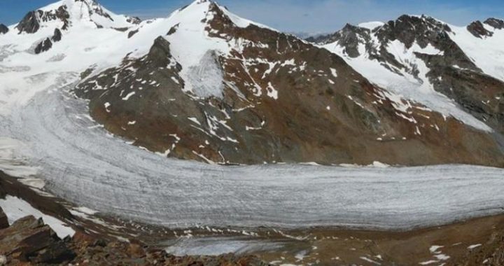
Gongka Scree, Deqin County
The British plant collector Frank Kingdon-Ward was fascinated with the alpine screes of northwest Yunnan, as have been many botanists since. Screes, the distinctive loose rock that covers mountain slopes, are an important part of the alpine ecosystem here. From afar it looks as if there could be no plantlife at all. In fact, screes are a habitat for unique and extraordinary species that survive near the upper limits of plant growth. In addition to extremecold, they also have to contend with a constantly shifting substrate, which may be responsible for the changes seen between 1911 and 2004. Kingdon-Ward described the dark stripe of vegetation running through the foreground scree as prostrate juniper and dwarf rhododendron. Very little remains of that shrubby patch today.One of the most unusual of the extraordinary scree plants is snow lotus(genus Sausurea). Puffy white with dense hairs, some species of snow lotus are highly sought after in Tibetan and Chinese medicine. It is used to treat headaches and high blood pressure and to regulate menstrual cycles. The whole snow lotus plant is collected just prior to seed set, preventing dispersal of a next generation of seed. This is an unfortunate turn of events for a plant that grows in one of the most unproductive habitats on Earth. Indeed, researchers from the Missouri Botanical Garden documented a decline in mature plant size over the past century. Plants that Kingdon-Ward collected from these screes were significantly larger than the ones growing there now.Further research on snow lotus population biology has produced a set of science-based guidelines for sustainable harvest by local Tibetans.
Sila,Deqin County
One of the main trails between the Lancang and Nu Rivers traverses a high pass called Sila. The trail was constructed by French Catholic misionaries for travel between their misions at Cizhong on the Lancang River and Baihanluo in the Nu valley. Frank Kingdon-Ward traveled this route in early June 1911 while the pass was still under dep snow. He photographed his expedition porters approaching the pas. In 2004, an expedition of alpine scientists from The Nature Conservancy and Cornell University traveled the same route 20 days later in June than Kingdon-Ward, when there was only slightly less snow.
Baima Valley, Deqin County
J.W. Gregory visited the base of Baima Snow Mountain in the middleof summer when monsoon storms covered the summits with clouds and Tibetan herders were on the high pastures. My visit occurred in the middle of autumn when clear skies prevailed, early snow remained on the north face, and herders have descended to lower country.A woven yak-hair tent is visible behind the herders in Gregory’s 1922 photo. These types of tents are still used today to cover stone foundations like the one pictured in my 2004photo. Frank Kingdon-Ward visited this valley 10 years before Gregory and was welcomed with great hospitality by herders who provided shelter, butter tea, and a warm fire. We experienced the same wonderful hospitality while working in the Tibetan high country nearly a century later.
Molitong, Deqin County
Molitong is a high meadow along the pilgrimage route around Khawa Karpo. In fact, it is a major staging area, with tens to hundreds of pilgrims spending the night here before ascending to the sacred Dokerla pass.A pilgrim is pictured in the modern scene. Local yak herders from Yongzhi village also use the meadow as a summer pasture. In winter, snow avalanches cross the foreground of this scene sweeping down a chute from the high ridge to the west(left).So what changed the foreground from forest and shrubland to an herbaceous meadow? The probable scenario was something like this: An extraordinarily large avalanche swept down and killed some of the large birch trees(Betula albosinensis) in its path. The shrubs could easily survive the avalanches but probably succumbed to harvesting for fuel. This was followed by yak grazing, which prevented woody plant regeneration and now maintains the meadow.
Peacock Mountain, Gongshan County
The pass below Peacock Mountain lies on one of Asia’s continental divides. To the east (left) lies the Lancang River, which flows to the Pacific Ocean through Laos, Cambodia and Viet Nam. To the west (right) lies the Nu River flowing through Myanmar into the Indian Ocean. In the rolling pass lies an extensive meadow system bounded by a stunted fir and rhododendron forest. The meadows are used for yak grazing. Animals were still on the divide when Emile Roux camped near the herder hut in latesummer 1895. He commented on the fine pasture of the area. The yaks were long gone by late October when both Rock’s and our expedition crosed the divide.The tall fir trees missing from the right side of the scene today were probably used for construction of herder huts. The stumps are still visible.Huts similar to the one in the 1895 scene are still scattered around the pass area. In fact, another scene from Peacock Mountain Pass, photographed by Kingdon-Ward in 1911, shows similar tree loss near herder huts.Rhododendron can be burned green for fuel, which probably caused its decline in cover from the Rock photo foreground.
Yulong Dry Valley, Yulong County
Water melting from the glaciers and snowfields of Yulong Snow Mountain never leaves this valley. The stream sinks into the coarse, glacial gravel that fills the valley bottom. Dry at the time of both Rock’s photo and our modern rephotograph, only with exceptional flooding does water flow as far down valley as this photopoint. In Chinese this valley is known as the Dry River Valley.This scene shows evidence of a natural catastrophe. When a large earthquake hit Lijiang on 3 February 1996(7.0 Richter scale), witnesses saw dust clouds rise up around the base of Yulong Snow Mountain. These clouds resulted from huge amounts of rock falling off the steep mountainsides.Falling rock, continually loosened by rain or snow, is a common occurrence in mountains, and the cone-shaped piles they create at the base of cliffs are a common sight in mountain valleys. However, the earthquake added several meters of rock to these piles in a single event, burying stands of conifer forest in the process. Changes in the debris cones are noticeable on both the left and right sides of the valley behind me.
Xuebang Mountain, Lanping County
This monsoonal pattern results in 99 percent of wildfires being started by humans during the dry season, either intentionally or accidentally. These images illustrate the purposeful use of fire to maintain grasslands for grazing on ground that otherwise would support forest.The grassy slope dominating the scene is pasture for the Yi village of Rewozi, located down valley to the left. Each of the 30 households in thevillage is allowed to own up to 80 sheep,20 cows, and some goats. Their pastures used to be maintained by fire, although that practice has become illegal within the past couple of decades. Evidence of recent fire can be seen in the 1923 photo as the blackened upper slopes of the middle ridge. On the other side of the scene,a small fir forest on the right was lost to fire about 50years ago, according to our guide. The grassy-looking bamboo understory remains today .