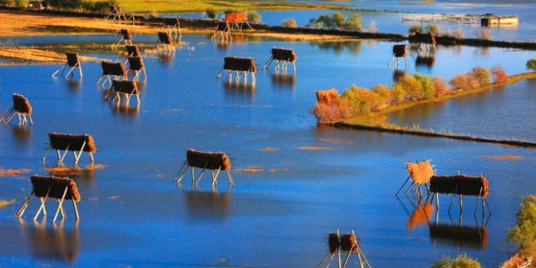
Shangri-La’s River Introduction
8 min readJinsha River at Qizong, Weixi County
This photo point is at the edge of downtown Qizong looking north, upstream. The village was along one variation of the Yunnan Tea and Horse Road to Deqin, although this path was not as heavily used as the route crossing the Jinsha-Lancang divide farther south. It is actually more important today as the location of one of only four bridges crossing theJinsha River in northwest Yunnan. The bridge links the new roads now seen on both sides of the river.The level of the Jinsha River is similar in the 1923 and modern scenes.Both were taken during the winter drought period typical of monsoonal Yunnan. The gravel island in the foreground also appears to be similar in both scenes, but is actually two to three times larger today than in 1923, extending downriver out of view to the right. In contrast, the alluvial terrace and gravel bar, upstream on the next river bend(indicated with arrows), areconsiderably reduced in size. This upstream-loss and downstream-accrual pattern is common on big mountain rivers like the Jinsha and is even more obvious in the repeat photographs of the Qizong Valley later in this book, albeit at a distance.Qizong lies at the intersection of four counties that also represent an ethnic crossroads, with Lisu to the west(Weixi County), Tibetans to the north and east(Deqin and Shangri-La counties), and Naxi to the south(Yulong County). The Tibetan-Naxi boundary has been the most important historically, with tensions reaching back at least five centuries to the Naxi kings. Tibetan brigands had completely burned Qizong in the April before Joseph Rock’s visit, when it was apparently a Naxi village. Today it is a mixed Naxi-Tibetan community.

Jinsha River at Cikou, Yulong County
Below the village of Cikou, the Yunnan Tea and Horse Road climbs to the top of a bluff where this view of the Jinsha River unfolds. The valley and the river have widened out in the 70 kilometers (43 miles) between here and the last photo sequence at Qizong. The striking green and yellow patchwork of cultivation in the distance is the winter crops of wheat and rape. Elevations here are warm enough to cultivate rice during summer instead of corn, whichis usually grown at higher elevations. Also of note, the large island on the right must flood regularly, permitting only intermittent cultivation.Joseph Rock was traveling up river in early October, near the end of the monsoon rains when the river was high. More gravel bars were exposed when we relocated the photo point in March, near the end of the winter drought. The Chinese characters,”jin-sha,”mean gold sand, thus this headwater river of the Yangtze basin is more rightly called in English the River of Golden Sand. The term gold could refer to the color, but it likely refers to the valuable mineral that is buried beneath the gravel exposed at low water. Gold has been extracted from these sands for centuries and is still done today.
Jinsha River at Axi, Yulong County
Winter in Yunnan doesn’t get any better than the day we relocated this photo point: spectacularly blue skies,a warm sun at this low elevation, and great views down river with Haba Snow Mountain looming in the distance.The Naxi farmers that occupy this valley add to the bucolic scene.A diverse crop of winter vegetables and small grains are growing in the terraced fields in the foreground of both photographs. The terraces will be filled with water in June and rice planted as the summer crop. Remarkably little has changedabout these terraces, except the gully bisecting them has widened somewhat and gotten deeper. At the bottom of the gulley is a clump of bamboo, alive in1923 and recently dead in 2003. Bamboo clones, like the one pictured, live for 70 to 80 years, then they flower all at once and die together. So, it’s likely that we photographed the same plant as Joseph Rock.
Jinsha River above Tiger Leaping Gorge,Shangri-La County
Flowing north after making an abrupt turn at its First Bend, the relatively mellow Jinsha River is confronted with a mountain mass through which it carved the famous Tiger Leaping Gorge. After Lijiang Ancient Town, this gorge is one of the top tourist attractions of the Lijiang area. Bounded by Haba Snow Mountain on the west and Yulong Snow Mountain on the east, the 17-kilometer(10-mile) long gorge is over 3,000 meters(10,000 feet)deep. Towering over the gorge in these photos are the northern peaks of the Yulong massif. Deep in the gorge lies a gigantic boulder in the center of theraging river. Its outer edges are thought to be close enough to both sides of the river that a tiger would be able to make the crossing in two impressive leaps.Dead center in the middle of these photographs, at the entrance to Tiger Leaping Gorge, is the proposed site of a large hydroelectric dam. Preliminary exploration and preparatory construction has begun. The next team that follows in our footsteps to rephotograph the Yunnan landscape will be presented with a very different scene.
Lancang River at Yangza,Deqin County
These photographs show three seasons of the Lancang River, each with a distinctive water level. Arrows are provided as a common point of reference.Joseph Rock traveled this section of the Yunnan Tea and Horse Road a month or so after the monsoon rains of summer had subsided and the river level was on its way down. By the end of the winter drought in March, it is even lower than what is pictured here. We relocated Rock’s photo point inspring when the river was considerably higher, but before the monsoon had begun. Mountain snows were melting and a weakening winter drought had brought modest spring rains. Reverend Roderick MacLeod traveled upriver in mid-July and took his photo a short distance upstream from Rock’s photo point. Although from a slightly different angle, it shows a river filling thegorge wall to wall at the height of monsoon rains and glacial melting in the headwaters. In this narrow stretch of the Lancang there is typically more than a 10-meter (33-foot) difference in river height between the winter low water and summer flood.The modern color images here and in the next photo sequence illustrate the color of the sediment-laden river water as it starts to surge in spring and summer. There are naturally high erosion rates at the headwaters of all three rivers because of very steep land and low vegetation cover.
Lancang River Valley at Ciku, Deqin County
Thirty kilometers (19 miles) downriver from Yangza the Lancang River emerges from the rain shadow of the Khawa Karpo range,a phenomenon that creates the arid canyon slopes seen in the last sequence. Here the valley widens and makes broad curves. More rainfall allows lush forest and arable, non-irrigated crop fields to descend to the river’s edge. Tibetan houses have obviously increased in the center of the scene and, unlike most repeated photographs in northwest Yunnan, there has been an increase in dryland agriculture on the valley sides.
Lancang River at Feilongqiao
Here the Lancang River is south of the big mountains and the valley has become even wider than at Ciku, which is 250 kilometers(155 miles)upriver. Barely visible in the very center of Joseph Rock’s image is the Feilongqiao-the Flying Dragon Bridge. In Rock’s day, there were only two bridges crossing the 4,700-km length of the Lancang/Mekong River.The most well used bridge was along the Dali-Baoshan Road that connects Burma with Kunming, the provincial capital. It eventually became known as the Burma Road during World War II. The Flying Dragon Bridge was70 kilometers(45 miles) north and presented Rock with a more direct route between Burma and Lijiang. Because of the ancient bridge, this section ofthe Lancang valley long had great strategic importance. Many bridges now cros the Lancang, and foreign travelers rarely visit this area today. In 1966, the bridge was destroyed by a flood and never rebuilt, although the bridge abutments and gatehouses still remain.
Nu River Valley at Changputong
Our From a vantage point on the slopes of the Gaoligong Mountains, Joseph Rock took his photo of Changputong showing the unusually broad basin in the otherwise steep, narrow valley of the Nu River. The main village visible in the 1923 photo is Changputong (lower center),a well-known villageat the time. Today the sprawling town of Bingzhongluo(right center) is the economic and political center of the basin, with Changputong left to obscurity.Then as now, Changputong lies at the political and ethnic boundary between Tibet and Yunnan. In 1765, the large Buddhist center in Batang(nowin Sichuan Province) set up a small monastery in Changputong. Established on the edge of the Tibetan world, it was never a thriving place. After a while, celibacy regulations were relaxed and monks were allowed to marry in order to increase the local Tibetan population. These regulations were in place until recently. The Chinese Army destroyed the monastery in 1905 in retaliation for the violent rampage of the monks, who destroyed the Catholic mission at Baihanluo and murdered its priest . The Changputong Monastery was still in ruins when Kingdon-Ward visited the village in 1911and 1913, as well as when Rock passed through in 1923. It is operationaltoday with eight lay monks ministering to 70 to 80 Lisu, Nu, and Tibetan Buddhists that worship at the monastery. There is also a Christian church with a similar number of mostly Lisu and Dulong worshipers.
Nu River Valley at Changputong, Gongshan County
Under the same clear blue, post-monsoon skies, we see close-up the Nu River segment seen in the previous sequence. The river has recently lost its muddy monsoonal appearance and turned the aquamarine color typical of streams flowing from glacial landscapes. All three great rivers in northwest Yunnan have their source in heavily glaciated mountains of the TibetanPlateau. As the glaciers grind their way down valley, they pulverize the underlying rock into a fine powder. This “flour”gives all the world’s glacier-fed rivers and streams this distinctive color.Nu River at Liuku, Lushui County
Kingdon-Ward took his 1911 photo of the ferry crossing on the Nu River at the village of Liuku. At the time, he described Liuku as a small village of “insignificant appearance”inhabited by Lisu people. The village’s only reason for being was because of the ferry crosing. Today Liuku is the capital of Nujiang Lisu Autonomous Prefecture and is the major political and economic hub of the valley, inhabited by 30,000 to 40,000 people. The river is narrow and quietly flowing here, the perfect place for a ferry. The single-lane vehicle bridge that replaced the ferry can be seen spanning the river in the center of the modern photograph. It was built in 1970. This bridge was recently replaced by a modern two-lane structure that crosses the river immediately behind the photo point.