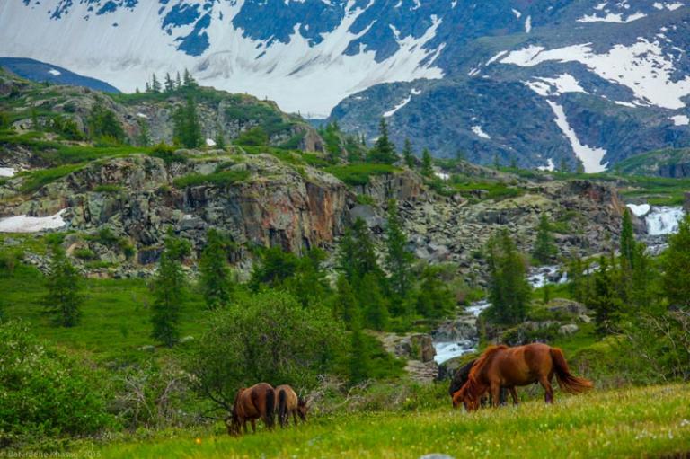
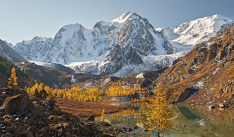
The Altay Mountains
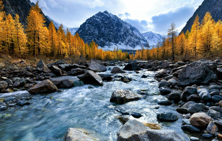
11 min readThe Altay Mountains is located in the north of Xinjiang Uygur Autonomous Region and the west of Mongolia, extending northwest to the territory of Russia; the whole mountains and Mongolia stretching for more than 2.000km. The Mountains in the territory of China is the Southern Slope of the middle section, which is neighboring Junggar Basin in the south,with an extension of more than 500km. The main ridge of the Mountains is over 3,000m highand the Friendship Peak in the north is the highest peak with an altitude of 4, 374m: the western part of the mountain is the widest, which becomes narrower and lower to the southeast the altitude of the mountains is between 109-4 506m. and the forest line is generally at the height of 1, 800-1,900m; it covers an area of 1,611, 457 ha., among which, 1002,000ha, belongs to top conservation area. The Mountains was formed in the ancientCaledonian-Hercynian period 200 million years ago(in this period, the crust here was under dramatic changes, and extremely unstable); the average annual temperature here is 0°C and 15°C-17°C in the area below the snowline in July, the lowest temperature in winter may reach-62°C, and the average annual precipitation is between 500-700mm.
The Altay Mountains has abundant forest and mineral resources. The word”Altay means”Gold Mountain”in Mongolian, and it is rich in gold, the gold mining started as early as Han Dynasty, and during Qing Dynasty, the population of gold diggers in the Mountains even reached up to fifty thousand.
There are contemporary glaciers in Altay Mountains and the Great Fault of Northwest in front of the mountain. It gradually descends towards south and west to the Irtysh River Valley with 4 flights of laddering stages; the mountain is shaped in blocks and layers, with the glacial topography presents only in the alpine region, accompanied with the contemporary glaciers. which is the concentrated area of contemporary glaciers in thenorth end of China. There is no large longitudinal valley except for the fault basins scattered like a string of beads along the north-west direction, and Altay Mountains can be called the typical block mountain, Altay mountains, together with Tianshan Mountains, Kunlun Mountains, Tarim Basin, and Junggar Basin form the unique landform of”Three Mountains Holding Two Basins”of Xinjiang.
The Altay Mountains is relatively rich in runoff, Irtysh River and Ulungur River are developed here, Both of the two rivers are typical asymmetric pectinate drainage Irtysh River is the only exorheic river in Xinjiang, the drainage area within the territory is 50,000 km-with the total length of 546 km. The main sources of water supply are precipitation snow melt water and glaciers, etc. and the average annual runoff for years is more than 10 billion m, accounting for 89% of the total runoff in the Altai region. The tributaries of Ulungur river are in the mountain area, while in front of the mountains is the runoff dissipation area, and the overall length of the river is 573km, which finally flows into Ulungur Lake(Brunt Sea, Fuhai), with the drainage area above the Ertai Station of 22000km”. The main source of supply is also the snow melt water, and the average annua runoff for years is 1.1 billion m There are many canyons and fault basins in the upstreamof the two rivers where the fall is large and water is clear with little sediment and the potential hydraulic power is about 500, 000kw.
The winter in this region is long and bitter cold under the influence of the asian anticyclone, namely the high pressure zone. The temperature in January is-14C in the hills and-32C in the eastern sheltered valleys; while in the Chu River steppe zone, the temperature can even fall to-60C. Occasionally, there are one or two permafrost zones belonging to the permafrost zone covering the vast area of northern Siberian. The temperature in July can be pleasantly warm or scorching -the daytime high temperature often reaches 24C, and sometimes to 40C in the area of low slope, but in most places in the highlands. summer is short and cool. The altay mountains is towering in the arid desert and arid semi-desert zones in the abdomen of Asia, the water vapor of the atlantic Oceanbrought by the west wind circulation drives straight to the altay mountains in the northlong Irtysh River Valley and Kazakhstan Zaysan Valley, so the precipitation is abundant, increasing with the height and decreasing from west to east: In the western part, especiallthe highland at an altitude of 1,524-1, 981m, the precipitation is large of about 500-1,000mm, and up to 2,032mm In the eastern part of mountain area, the total precipitation is only 1/3 of that in the western highland. and in some areas there is even no snow at all the precipitation is concentrated in summer and winter, little in spring and autumn; snowfall is more than rainfall. and the duration of snow cover will lasts with the increase of altitude which can be 6 to 8 months in the medium and high mountain area, while only 5 to 6 months in the lower area: the snow line is at an altitude of 2, 800m which is the lowest one in china The temperature decreases with the increasing of altitude. The climate in this region changes obviously in vertical gradient with the characteristic that the winter is long, summer is short, while spring and autumn are not obvious. There are about 1,500 glaciers covering the wing of peaks, with an area of about 648 km.
There are 4 quite distinct vegetation zones in the Altay Mountains: Mountain Sub desert Zone. Mountain Grassland Zone. Mountain Forest Zone. and alpine zone The first vegetation zone can be found in the low slopes and valleys of Altay Mountains in Mongolia and Gobi Altay mountains, the summer is hot and dry, there are only sparse plants includin some drought-enduring and salt-enduring grass and trees the mountain grassland Zone is about 610m high in the north and up to 2, 012m in the south and east, and the meadow and mixed grass prairie are characterized by turf grass, forage grass, and shrub. The Mountain Forest Zone is constituted by Taiga Forest (also known as the boreal forest, namely the marsh coniferous forest), which is the peculiar forest of Altai Mountains, covering about 70% of the mountain area, and mainly in the low and medium areas Forests can reach an altitude of 1, 981m, and it can extend to an altitude of about 2, 438m on the dry slopes in central and eastern Altay Mountains. The most common ones are the conifer species dahurian larch and fir and pine (including Siberian lycopodium japonicum), but there are also large areas of secondary birch forests and poplar forest. Actually, there is no forest zone in Altay Mountains of Mongolian part and Gobi Altay mountains, however, there are sporadic coniferous trees growing in valleys. Alpine plants-subalpine bush is less than the meadow as summer pasture, and then the moss, bare rocks, and ice -which can only be seen at the highest mountains.
In Xin jiang China, the vegetations growing at an altitude of over 3,000-3, 500m are mosses cushion plants; it is the alpine -subalpine meadow at an altitude of 2,600-3,500m; it is the forest steppe zone at an altitude of 1, 300-2, 600m; and shrub steppe at an altitude of 800-1300m: the lower limit of distribution of vegetation rises from west to east for example, the lower limit of forest is 1, 200-1, 900m, and that of the shrub steppe is 500-1, 500m, while the upper limit of desert is 500-1, 100m.
The natural resources in Altay Mountains are rich and varied. and there are a variety of minerals and good pastures; the high-quality timber forest resources play an important role in Xinjiang; water resource is also abundant.
The altay mountains is rich in animal resources, there are various rodents living in the semi-desert zone and the steppe zone of the mountains birds here include eagles. hawks and kestrels. Most of the species originate from Mongolia, such as marmot, jerboa(a kind of rodents good at jumping), and antelopes. Siberia mammals(bears, lynxes, deer andsquirrels) and birds(hazel grouses and woodpeckers) also come frequently to the moist coniferous forest, and alpine animals include mountain goats, snow leopards and goats The Altay Mountains is rich in minerals, such as the gold, precious stones, and non ferrous metals, and there is the saying that”there are seventy two ditches in the altay Mountains, and all of which are full of gold”. The Altay Mountains has already been famous for its high gold reserves, and it was recorded in Qing Dynasty that”There are more than ten thousand gold mining workers, producing more than ten thousand liang of gold; and there are ten mining areas with tens of thousands of miners”. In addition to gold, altaiMountain is also the important distribution area of non-ferrous and rare metals in China and the total reserves account for a large proportion in China. The Koktokay mining area in the Altay Mountains is the famous No. 3 vein of world, containing more than 70 kinds of minerals such as beryllium, lithium, niobium, rubidium, and cesium, which is praised as the rare Natural Museum of Rare Metals”in the world. Kelumute mining area is the second production base of rare metals in Xinjiang, and the production of niobium ore concentrate always ranks the first among the same kind of mines in China.
The Altay Mountains has unique scenery, and the famous scenic spot Kanas Lake is located in the south slope of the main peak Friendship Peak, Burqin County of Altay Prefecture of Xinjiang.
Kalamaili mountain
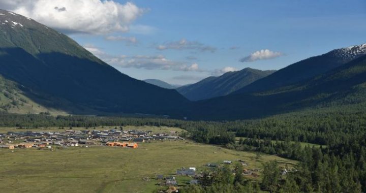
Kalamaili mountain is located in the area under administration of the sixth division of Agricultural Construction of Xinjiang Production and Construction Corps. There is a national nature reserve and a hoofed wild animals nature reserve distributed in the eastern Region, there are wild horses, wild asses, argali, goitered gazelle and other desert rareanimals There are also many places of interest such as the north Court supervision officeof the Tang Dynasty(618AD-907AD), the historic site of the North Court Fortress, the West Grand Temple of the North Court, Qitai Thousand Buddha Caves, Cheshi ancient path, and numerous ruins of ancient beacon towers, ancient tombs and primitive villages, etc.
Fuhai
Fuhai is the Ulungur Lake, and it is also named Burultoqay or Dahaizi(the neighboring Jili Lake is called Xiaohaizi), which is located in the Fuhai County, Altay Prefecture of Xin jiang, with the northern latitude of 47°02′-47°25′, east longitude of 87°02′-87°35′ and the altitude of the lake surface is 468m it looks like a triangle which is 30kr wide from north to south and 3 5km long from east to west, with the lake area of 821k7em and an average depth of 8m.
Ulungur Lake is the only place which must be passed when shuttling between Altay City and Karamay City. Its charm lies in the”tolerance of sea”and the famous”Fuhai fish The entire east coast and estuaries of Xiaohaizi are full of reeds and weeds. flocks of wild ducks, flying sea gulls, and other rare birds such as white swans and spot cranes, etc, and it can be called the “paradise of birds”in summer and fall. There are also more than a dozen valuable fishes in the lake The east coast of Dahaizi is a beach composed of delicate and soft quartz and with no sludge. The bottom slope of the lake declines gently, and the water is crystal clear. There is a silver beach of 10km long in the north, suitable for swimming surfing and skateboarding. boating and other recreational water activities.
Butterfly Spring Valley
part of the Altay Mountains. It is at an altitude of about 1,310m, and has a straight-line Butterfly Spring Valley is located at a small tributary of Zhuoerte River in the middle distance of 160km from Fuhai County. Because of the poor transportation condition, at present, the tourism development status is still relatively primitive, but its potential tourism value and unique tourism attraction have been universally acknowledged The most amazing of the Butterfly Spring valley is that there are twenty-four sites of spring source on the hillside. most of which are hot springs with water temperature from 30°C-60°C. Each spring has its own unique feature: there is a”fountain “with clear water, and it will spout a water column of 80cm high from the spring source of a diameter of 4cmevery three seconds; a”stomach spring”, the normal person have no reaction after drinking the water, but it is said that the spring water can cure stomach illness: a”milk spring”, the water is milky white, sweet and refreshing: a”snake spring”, there are two docile snakes lying in it; a”cold spring”, it is extremely chilly around the spring, the water is crystal clear and refreshing with an icy coldness; what’s more amazing is the spruce of 40cm in diameter growing in the crack at the upper part of the spring; a”hot spring”, the water is warm and limpid which can significantly remove the sebum and dirt of human body a blood spring, the water is reddish because of its location in the red veins: a”heart springthe water outflows from the gaps of rocks in intervals like the heart beating. A Spa Center with rooms for hot spring bath and with each serving more than a dozen tourists has beenbuilt beside the largest hot spring and the water temperature stays around 50C. Tourists will feel quite comfortable and released after having a bath here.
The most beautiful things in the butterfly spring valley are butterflies. during each June to July, there are often dozens of colorful butterflies gathering here, including the king of butterfly -the Wind Butterfly, while the most in quantity is the jade colorful butterfly. The gathered butterflies are just like the snowflakes flying over the colorful blossom in mountains and valleys, tourists will feel completely relaxed and be enchanted and feel as if they haved being in some fairyland.
Birch forest Park and Xiaodonggou Scenic spot
Altay Natural Forest Park is a national Aaa level scenic spot.It is located on the twoislands(formerly known as Dutong island)of the river valley in the course where Kelan River runs out of mountains.White birches and poplars grow luxuriantly in the park,with birches the dominant.It belongs to the secondary forest of river valley,and there arebushes(mainly the fructus crataegi cuneatae)and grass grow heaily under the trees.The park is surrounded by waters,which offer the fertile soil and water for the flourishing growth of grass and trees,they cover the sky and make moist air and a cool climate;it is really a good place for summering and spending vacations.
Xiaodonggou Scenic Spot is about 1lkm from the downtown of Altay City. There are dense birches and poplars in the valley, and occasionally grow several spruces. Walkin toward the upstream, the spruces, pines and other conifers grow in number and broad-leaf species reduce. The trees here are growing in a primitive state, in spring, the stream water s mainly the melt ice and snow as well as the underground spring water from high mountains, which is so clear and sweet that can be drank directly. Camping here, you can lie down relaxedly and watch the bright moon and stars, listen to the gurgling of the stream and enjoy the fun of wild life, and the pleasant feeling of returning to nature.