Altun mountains Nature reserve
14 min readAltun mountains nature reserve is located in the south of altun mountains and the north of the eastern Kunlun Mountains, stretching from the boundary of ruoqiang county and Qiemo County in the west, adjacent to Qinghai in the east, and Tibet in the south; it is 360km long from east to west, and 190km from north to south with a total area of 45,000km; It is the largest comprehensive nature reserve at present in China.
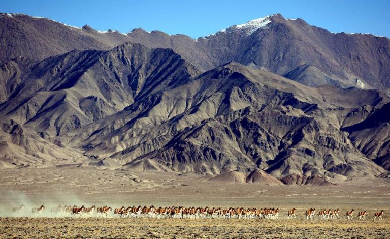
The reserve is a closed basin surrounded by mountains with altitude of over 5,000m and the average altitude of the reserve is 4,500m; there are 241 kinds of wild plants, and over 60 kinds of wild animals have been surveyed, There are 7 species of national first class protected animals, including wild yak(about 10,000), Equus kiang(about 30,000), Pantholops hodgsonii (about 90,000), snow leopard, argali, Tibetan snow cock, and black necked crane; and 11 species of national second class protected animals, and 4 species of national third class protected animals. There are 14 kinds of mineral resources, such as jade, quartz crystal, mica, iron, zinc, and urao, among which, jade, gold and asbestos are the most famous. The primitive ecological system is well preserved in the reserve, which has a great scientific value. The”Demon Canyon”and the”Lake of Yin and Yang(the dead and the living)”add more mysterious color and charm to the Altun Mountains Nature Reserve.
Altun mountains
Altun Mountains is from the upstream of Qiemo River to the Dang jinshan Pass in the east, bordering with Qilian Mountains, and it forms the boundary between the Tarim Basin and Qaidam Basin with a length of about 270km, and the maximum width is 100km. The Mountains becomes lower from west to east. the ridge line is 3..000m above sea level, and Yousubale Peak of 6,161m above sea level in southeast of the Ruoqiang County is the highest peak, Altun Mountains is called”South Mountains”in the Book of Han, Xuanzang passed through it when he travelled to the west. The climate here is dry with little amount of precipitation, and the entire mountain land is mainly covered with desertvegetation, reserving a complete and primitive plateau ecological environment. The largest nature reserve in China-Altun mountains nature reserve and altun mountains wild camel Nature Reserve are located in the Altun Mountains within the territory of Ruoqiang County In the reserve, there are tens of thousands of Tibet wild asses, Tibetan antelopes, wild yaks wild camels, black-necked cranes and other national first class protected animals in addition to the peculiar alpine desert, dozens of mountain lakes and primitive natural landscapes, therefore, it has a high value of scientific survey and adventure tourism. It is reported that people have found traces of”snowmen”in Altun Mountains in recent years, which especially casts a layer of mystery to the pathless Altun Mountains The natural landscapes in Altun Mountains Nature Reserve are quite beautiful, and there is the”beach”desert with the highest altitude in the world, the inland plateau unfrozen lake-Aqike Lake, the”Guilin in plateau “Xinqing Feng, glacier-covered Muztag Peak, as well as the Thousand Teardrops spring”, “lake of Yin and Yang”, and the “Demon Canyon”and other scenic spots, meanwhile, in the mountains, there have been discoved quite a lot of rocks carved with tantra mantras in Tibetan.
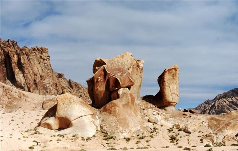
The Karst Landform in altun mountains
The Karst landform is located in the agger mountains in altun mountains Nature mountains of 4.400-5000m above sea level from Buka Daban Peak in the east to the c Reserve. It is 350km long, 20-30km wide, with an area of about 10,000km”hidden in the Aqikekule Lake in the west. The Karst Landform here is the spectacular landscapes in different poses formed by ancient limestone that went through the exposure to winds andrains, dissolution and differentiation for thousands of years. Take a broad view of the landscape, rock peaks are standing in great numbers and penetrating into the blue sky, some like camels and elephants, some like dragons and crouching tiger, some like bridges and flagpoles, and some like the pavilions of the immortals as well as the elegant lofts, all of which are quite vivid in shape and smartly inspiring people’s imagination. What’s more spectacular are the wonderful scenes of abrupt horns, steep cliffs, glaciers hanging upside down, and the numerous valleys formed by the intertwining of karst landform with glacial landform, which really could be described as themasterpiece of nature and the wonder in the mortal world.
The plateau desert of altun mountains
The plateau desert is located in the altun mountains Nature reserve in southern Ruoqiang County, it is the desert with the highest altitude in the world, and the most famous spots are Kumukuli Desert and the “beach”of crescent-shaped dune Kumukuli Desert is located in the northeastern part of the reserve, lying on the southern slope of the Qimantag Mountain of 3, 916-4,706m above sea level, and irregular rectangle shaped with a total area of about 2.556km”The average thickness of the desert is 300m and the maximum thickness is over 500m, Dotted with plots of oases, the standing pyramid-shaped dunes and the complex dune of the crescent shape are really the great wonders of the pl lateau desert.
The crescent dune is located to the east of the whale lake and to the north of the towering snow mountain, with a total area of 120km”, and an altitude of 4. 800-5,000m which is about 2. 000m higher than the so-called the world’s highest desert-Atacama Desert in South America(with an altitude of 3, 000m or so). The desert is continuously accumulated and rises with a large mobility, covered the modern river beds and ice-borne sediments. The phreatic water under the dune is quite rich, making a crescent shaped puddle according to the terrain, so it is called the crescent spring. In summer, the spring water is blue and clear, and in winter, the spring looks like the reflected silver moon which can be compared favorably with the Crescent Spring in Dunhuang Mingsha Mountain.
The “Demon Canyon”in Altun Mountains
The”Demon Canyon”is located in the area of Kunlun Mountains at the south end of Altun Mountains Nature Reserve and the junction of Ruoqiang County and Qinghai Province: it is 100km long and 30km wide from the Kumukuxi desert in the west to buluntai in the east with an altitude of 3.000.000m In this land of 3. 000km”. lakes of all sizes scatter all over like stars in the sky, and there is Nalengele River crossing the land; there is abundant rainfall, humid climate, lush grass, and blooming flowers, all of which make it a green carpet. However, this vast green land is called the”Demon Canyon”, farmers and herdsmen try to keep away from it, which make it a desolate and restricted zone full of eerie and horrible atmosphere.
Since the founding of the People’s Republic of China in 1949, scientific and technical personnel have been organized to inspect this area, and the mystery of the”Demon Canyonhas been preliminarily unveiled. First, the”Demon Canyon”is surrounded by the towering major ridge of Kunlun Mountains to the south and Qimantag Mountains to the north which blocks the hot air from Qaidam Basin, so the humid air is trapped within the Canyon forming the numerous thunderstorms. The geological composition of the Canyon is mainly the strong magnetic basalt. and there are also more than 30 large and small iron veins and quartz veins, together with the effect of underground magnetic field, so there are often the thunderstorms”making the exposed protruding or towering objects on ground its targets Second, there are too many underground rivers and mires, whenever the arrival of sprin and thawing, people and livestock would easily fall into the underground rivers and mires where were covered up by aquatic weeds, so no one dares to access, and this is why the place became a mysterious restricted zone. Now, the scientific and technical personnel are taking further exploration and research here, so it is sure that the mystery of the”Demon Canyon “will be unveiled thoroughly.
The Earthquake Fault of Altun mountains
The Earthquake Fault of Altun Mountains is nearly 1,000km long, and hundreds of kilometers wide, belonging to the strike-slip active fault zone. There should be frequent serious earthquakes in such an area, but there is few, which has aroused great interest among Chinese and foreign experts on the Altun fault.
Microlith ruins in Altun mountains
Microlith Ruins in Altun Mountains scatter in the area of the foot of Klukpitletage Mountain, Karlton, and Buffalo spring in Altun Mountains Nature reserve. klukpitletage Mountain is located in east longitude 90 15, northern latitude 36 44 and Buffalo Spring ruins is in east longitude87°54′30″, northern latitude36°53′45″ The Karlton Ruins is located in the area of the same latitude 200km east of the Buffalo Spring ruins The three ruins are all at the altitude of over 4,300m. the weather there is dry and cold with thin air the ecological environment is harsh, and it is really a remote and desolate region But archaeologists have found and collected a wealth of specimens of microlith in this region, including stone cores, scrapers, stone leaves, stone arrowheads, blades, etc. Now, most of these specimens are kept in the Xinjiang Uygur Autonomous region Museum and the Xinjiang Institute of Archaeology. Those specimens are mainly made of flint and rock quartz through the process of chipping and grinding, so they have obvious characteristics of early culture.
Rivers in altun mountains
lie, there are 8 major rivers in Altun Mountains Nature Reserve, forming the”main artery in the plateau basins, and nourishing the vast alpine meadows. The drainage area of these 8 rivers is twenty thousand square kilometers. The rivers are mainly supplied by glacier melted water and spring dew water. The fluvial morphology in the reserve is various, with the rivers flow directly into basins. Some go underground now and then, and sometimes come up to the ground abruptly, flowing slowly to the depression of the basin; some have a high purity and the degree of mineralization of some rivers may be up to 715g/. Sulubeitike River is the largest river in the reserve, which is 280km long from the Northern Slope of Xinqingfeng Mountain to Ayakumu Lake with a drainage area of 6, 250km”. There are numerous lakes sacattered in the reserve with a total area of 1.200km”accounting for 27% of the entire area of the reserve, which play a vital role in regulating the climate in the region.
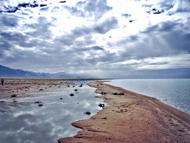
Lakes in altun mountains
Ayakumu Lake is the largest lake located in the north of the reserve with an area of 536km² ; and Agikkule lake is located in the western area of the reserve with an area of352m² and degree of mineralization of 81 6 g/. there are two islands in the lake which look in the distance like the naval vessels cleaving through the waves a large number of birds nest in the two islands the whale lake is located in the south of the reserve which is named because the shape of the lake looks like a whale Kumu Lake and Kqikkumu Lake are located on the Kumukuli Sand Hill, and they are called”Sand Lake”and”Little Sand Lake in Uygur.
The dune lakes group contains 145 small lakes in crescent-shaped distribution in the desert of 4,900m above sea level, and there are also several residual glacier terminal moraine lakes of the ice age under the influence of fracture fissure water control function and the blocking of fault, the groundwater volumes in the north and south of the reserve differ greatly, and there are many fracture springs at the south side along the fracture. The gushing spring water from the bottom of the limestone is a good groundwater resource There are 3 springs at an altitude of 3, 920m in the Sand Spring at the corner of the northern slope of Kumukuli Sand Hill in the northeast of the reserve, and the spring is surrounded by the sand hill in east, south and west, so it looks like a funnel opening to northward. The largest spring source is over 200m in diameter, and the other two springs sources are of 50m in diameter. It is the depression spring that overflows into thousands of strands from the slope angle, and one will sink if he stands in it. “Mingbulake”means”thousands of springs”, for the distribution of nearly one thousand springs at the edge of the depression The aquatic plants here are lush, so it is a good place for animals to feed. There are al many alpine hot springs in the volcanic areas, which need to be explored.
The Wonders of whale lake
There is a magical lake lying on the hinterland of Kunlun Mountains in the southeast the Ruoqiang County. It is 37km long from east to west, 7. 6km long from north to south with an area of 260km”at the altitude of 4, 708m, and it is 1-10m deep. The lake and the snow-capped mountains glorify each other; the shape of the lake is like a transverse whale with the head to east and the tail to west so it is called the “Whale lake”At the one seventh area of its east part, there forms a natural gravel dam of 7.5km long divided the lake into the east and west two parts naturally. The gravel dam is 2-4m above the lake with a width of 200m, and there is an opening in the middle part of the dam that the waters of the two parts are linked and can interflow. There is a variety of fish and aquatic plants at the”whale head”in the east part because of the inflow of Yulang River; every summer, numerous brown headed gulls tadorna ferrugineas and other birds will forage and breed here. The”whale body in the west part is a dead lake without any life, because there is no fresh water supply and the evaporation is strong, so after a long time, the salinity of the lake almost reaches the saturation point. Because of the significant difference in water quality of the two parts, the sharp contrast of “gulls and ducks are singing and dancing”in the east lake while”ten thousand horses stop whinny”at the west lake has been formed naturally, therefore, people also call it the”Lake of Yin and Yang(the living and the dead).
Wild camel
The Wild Camel is also called the Wild Bactrian Camel. the large even toed ungulates belonging to Camelidae. It is quite large and similar to the domestic Bactrian camel(two-humped camel). Its head is small, ears are short, with a cleft in the middle of the upper li and there are valves in nares to prevent ingoing sand. It has double humps and a short tal Limbs are slender, and wide and thick pads are under the feet. It wears a fine and soft villusof light brown, a little gray in the tail part, the top of the fur in elbow joints is brownish-black, and the cercus is brown, Millions of years ago, the camels ancestors lived in the Arizona desert in North America, and they were only lm high or so. About 100 years ago, it was believed that the wild camels were basically extinct. In 1883, Russian explorer Przhevalsky found the wild camels in Lop Nor, and named them”Western Subspecies of Wild Bactrian Camels”. At that time, there were hordes of wild camels in the desert of Lop Nor.
In history, wild camels were distributed in the entire Central Asia and the low-lying hills and plain areas of the east part of west Asia, from the Caspian Sea in the west to Yellow river in Shannxi in the east. and from the northern tibetan plateau in the south to Paikal Lake in the north. Today they live only in 4d distribution habitats: about 100 in Gashun Gobi in northern Lop nor about 300 in the junction of the north slope of altun Mountains and Gansu aksai annan dam, and the eastern taklimakan desert about 300 in the territory of Aksai and dunhuang Wanyaodun: and about 100 in the border region of thejunction of northwestern Hami Prefecture to Beita Mountain with Mongolia. 100 years ago, there were more than 10,000 wild camels, but now, such national-level protected wild animals are very rare, so the protection work needs to be strengthened.
The wild camel is tall and big, but timid and alert, and it can run as fast as 25km per hour. A wild camel has 2-3 more gene strands than the family camel. The most unusual thing is that it can survive by drinking salt water. The humps of the wild camel are mainly composed of fat and connective tissue And the humps can be up to 50kg in weight when in accumulation and reract. and the contents of the humps can be gradually transformed into the thermal energy that the body needs when in hunger and nutrition deficient. The olfactory sensation of wild camels is very sensitive, so they can flee as soon as possible before the arrival of the sandstorm. There is sand and stones flying in the sandstorm, so the clever wild camels will lie on the ground if it is too late for them to escape. Wild camels can shed tears, so there are always strings of tears under the long lashes. In fact, they are not real tears, but a way to protect the eyes by washing dust. Wild camels would eat varied food to handle their hunger, such as halogeton, schnabelia, wolf grass, reeds calligonum mongolicum, alhagi sparsifolia, and rose willow, and other psammophytes. Another interesting point is that wild camels have been able to migrate along the same route for centuries. When they walking in the desert, the adult camel will be in front and behind while the young camels in the middle; they always forage and drink along several fixed routes, which are called the”camel paths ” .
Every winter, wild camels will migrate from the altun Mountains in hordes to Lop nor for overwintering. Wild camels have a strong ability of mating and reproductive. The estrusand mating season is from January to March at the end of every winter, the gestation period is 13 months, and a female camel will give birth to only one cub during the next February to April, and the small camel will be intensively cared by the female camel. The baby camel can stand up 2 hours after birth. And a year later, the young camel can live a completely independent life. Once the young camel is two years old, it will be expelled from the community to compete for”leadership “in some other community. It will sexual mature at the age of 4-5, and the life span is 30-40 years; female camels will breed once every 2 years.
Altun international hunting field
Altun International Hunting Field is located in the area between Tateleksu in the northe slope of Altun Mountains and Jiangalesayi, which is 150km away from Qiemo County, and has an average altitude of about 3, 000m, with an area of 100km”The mountains are steep under serious erosion. Mountain vegetations contain Artemisia nanschanica, Stipa roborowskyi, Achnatherum splendens and so on. There are populus diversifolia, reeds Calamagrostis, and Tangkete thorn growing in the river valley. On April 26, 1993, the State Forestry Department officially approved the establishment of the Altun Qiemo Hunting Field. It is open to tourists at home and abroad, while hunters can enter with the related certificates. The Spanish tourist Valentine was the first hunter of the Hunting Field.
The climate here is the typical desert plateau climate, with strong ultraviolet radiation, frequent heavy rains, and large temperature difference between day and night. The best season for visit is from June to September.