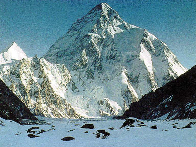
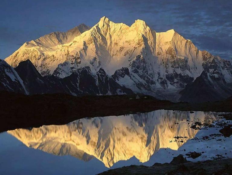
Qogir Feng
7 min readQogir Feng is the world’s second highest peak which is only lower than Qomolangmawith an elevation of 8.611m it is located in the kunlun mountains in the south of Tashikuergan Ta jik Autonomous County, thus it is also the watershed between China and Pakistan. After the opening in the 1950s, many mountaineering teams in various countries have climbed it.
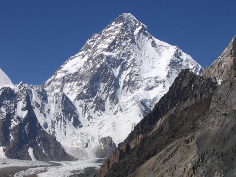
Qogir”is a word in Tajik language, meaning”tall and majestic”, and it is the main peakof the Karakorum Mountains which is called Peak K2 in foreign countries. Qogir Feng is located at northern latitude35°53′ and east longitude76°31′ in the middle section of the Karakorum Mountains. On July 31, 1954, the Italian explorers Lino Lacedelli and achille Compagnoni first reached the peak Qogir Feng is one of the peaks that are hardest to climb in the world, which is universally acknowledged among the international mountaineering circle.
The English name of the peak is Qogir Feng, and the word”Qogir”is usually considered to be Tajik language, meaning”tall and majestic”, but many people believe that it is a Tibetan word meaning”white goddess”, the reason why there is such a saying is that there are the Tibetan descendants at the south side of the peak, and they have once lived in theregion for nomadic activities. furthermore. their language is considered to be tibetan for the similarity to Tibetan. Now the Qogir Feng is generally called K2 in the international mountaineering circle. In 1856, the Indians inspected the situation of Qogir Feng, and the comprehensive inspection was finished by the British Henry Haversham Godwin-Austen in 1861. who carried out the detailed inspection on peak situation and climatic conditions of the south side of Karakoram mountains thus it was called austen peak at one time it was never acknowledged by the majority, if a peak is named after some individual’s name, and the foreign mountaineering circle proposed to name the Karakorum mountains on the basis of the order of inspections, thus they are named as KI to K5, and the other four peaks are Masherbrum Peak(K1), Broad Peak(K3), Gasherbrum II Peak(K4), and Gasherbrum peak(K5) Because the Qogir Feng is the second inspected peak in the Karakorum Mountains, so the internationally recognized name is K2. K is the initial English letter of Karakoram, referred to the Karakoram mountains ridge of Karakoram Mountains which is the boundary line of China and Pakistan as wer ain There are six main ridges in Qogir Feng, and the northwest-southeast ridge is the The other ridges are north ridge, west ridge, and northwest ridge. The peak is pyramidshaped, and steep with glacial cliffs. The steep slope is full of chute traces made by avalanches The top of the peak is an ice slope slightly rising from north to south with alarge area. The north part looks like being chopped by an ax, with an average gradient of over 45 degrees. The vertical elevation even reaches 4, 700m from the northern base camp to the top, thus it is the peak of the largest vertical elevation difference among the peaks of over 8,000m. The northern glacier is called Qogir glacier with the complex and changeable terrain. The glacier surface is broken and full of clear and hidden crevasses The valley on the west side of the glacier is a steep cliff where the boulders tumbling, glacier avalanches, and avalanches occur frequently. On both sides of Qogir Feng is the Yinsuegetty glacier of 44 km long.
The Karakorum mountains stretches thousands of kilometers in the northwest southeast direction with the general elevation of over 6,000m. The peaks here are concentrated, and in addition to Qogir Feng, there are other three peaks of above 8,000m arranged closely which are considered to be the world-class famous high mountains; In the east side of Qogir Feng, there are Broad Peak of 8,051m in elevation; Gasherbrum Peak of 8068 m: and Gasherbrum il of 8.035 m.
One-third of the 14 peaks in the world with the elevation of over 8,000m are located here. There are more than 20 peaks over 7, 000m, such as the Skilkanli Peak in the north with an altitude of 7, 545m, Spande Peak in the west with at an altitude of 7, 385m, and there is also the coronet peak at an altitude of 7.295m Therefore this region becomes the secondlimbing center that attracts the mountaineers all over the world. The approach route of Qogir Feng is the longest one among the peaks opening to the world at present. And the details of the route are listed as follows: firstly drive from Nan jiang ‘s strategical-important town Karghalik (Yecheng) to Mazar along Xin-Zang highway(National Highway 219), and then travel for another 25km along a simple road to Mazar Darla. And then walk 90km for six days from here, finally reach the mountaineering base camp of Qogir Feng Yinhong Beach at an altitude of 3, 924m) In order to pass this section, one shall climb over Arguelle daban with a elevation of 4, 800m to enter the Shaksgam valley, where is prohibited of entry during July and August during which it is the period of flooding of Kelechin River(Shaksgam Valley), and neither humans nor animals are able to pass by then The terrain of Qogir Feng is perilous, and the climate is also very bad. The rainy season of this region occurs in each May to September owing to the influence of the warm and moist airflow brought in by the southwest monsoon. After mid-September to the next mid-April, the strong west wind blows in, and brings the harsh winter. The lowest temperature on the top of the peak can reach-50C, and there are always the upper winds of over grade 8 in the area of over 7,000m, with the wind speed reaching 60km per hour or more, and sometimes 25 m/s; The snowfall may last for four or five days, and the peak is shrouded in thick fog throughout the year, which is the climate restricted period for climbing. From May to September, it is difficult to enter the mountain because the melting snow and precipitation often make the water level in valleys rise dramatically. Therefore, the best arrangement of mountaineering is entering the mountain during may to early June, because the water level does not rise severely, or during July to September, when the temperature on the top is a little higher and the good weather lasts longer, which is perfect for climbing the mountains.
In 1902, British mountaineering team first climbed the qogir Feng but failed In the following 50 years, people had tried for many times but never succeeded. Until July 31, 1954 the Italian explorers Lino Lacedelli and Achille Compagnoni first ascended the peak along the East ridge from the side of Pakistan, spending nearly 100 days In 1976 and 1977, China Mountaineering Association built up teams respectively to explore the new route by climbing from north side of Qogir Feng. On August 4, 1982, the Japanese Mountaineering Team of Sierra Club first reached the peak along the north ridge from the North Slope.
In 1979, Reinhold Messner led a team of six people and tried to climb along the north-west ridge(which he called”the devil route”), but soon he realized the risk of alpine collaboration and with the vomiting of several members he decided to change to the traditional route, and reached the peak together with Michl Dacher In 1981, Eiho Otani and Sabir reached the peak.
In 1982, the Japanese Mountaineering Team of Sierra Club first reached the peak along he North Slope which is within Chinese territory.
In 1986, a total of 14 people reached the peak and Wanda Rutkiewicz was the first woman, and then Liliane barnard was the second woman who reached the peak with her husband, however, lost their lifes on the way back, And Benoî: t Chamoux, who made a record of reaching the peak within only 23 hours; Josef Rakoncaj reached the peak for thesecond time, and till now, he is still the record holder of reaching the peak of K2 twice In 1993, a total of 16 reached the peak, and Jonathan Pratt as well as the American Dan Mazur made a heroic undertaking along the West Ridge: They reached the peak directly from the Attack Camp and returned to camp in just 32 hours There were several climbing accidents in 1995. In July, several teams succeeded in climbing. In the night of August 13, six climbers reached the peak, which was confirmed through wireless interphone. But when they returned, a fierce gale struck the top of the mountain and blew 5 of them down. In the same year, a German commercial expedition failed in climbing the north ridge.
As the second highest peak in China, there were no Chinese people reached the peak successfully throughout the 20th century, until July 27, 2004, the Tibet Mountaineerin Expedition ascended the peak at the local time of 6: 50(BJT9: 50). The success had also created a new record in China’s mountaineering history that three people reached 13 peaks of over 8,000m. The”China Tibet E xpedition for climbing 14 peaks of over 8,000m in the world”was founded in 1993 and was the first mountaineering team of reaching 13 peaks in group.
On August 2, 2008, 17 climbers summated the peak, but encountered an avalanche when they returned, and 1l of them died, which was the accident having the largest number o deaths in the history of mountaineering the qogir Feng.
On July 30, 2012, Yang Chunfeng, together with his teammates Zhang Jingchuan and Rao Jianfeng successfully reached the peak along the southern slope, which was the first folk mountaineering team in China that had succeed in climbing At present, among the peaks of opening to the world in China, Qogir Feng has the longest approach route. And the details of the route are described as follows: firstly, drive from Nanjiang’s strategically-important town Karghalik (Yecheng) to Mazar along XinZang highway(National Highway 219), and then travel for another 25km along a simple road to Mazar Darla, And then walk 90km for six days from here, finally reach the mountaineering base camp of Qogir Feng (Yinhong Beach at an altitude of 3, 924m).