Planning of the old urban area of Beijing
6 min readFrom the planning of Dadu City,we can see clearly that on the east bank of the Heavenly Water Pond was built the emperor’s palace while on its west bank stood two groups of palatial buildings facing each other,which were respectively inhabited by the empress dowager and the crown prince.A small round island situated in the middle of the lake served as the link of the three palaces. a wooden bridge was put up to connect the east end of the island and the east bank of the lake, while another wooden bridge was built to link the west end of the island with the west bank of the lake. To the north of the small island, a stone bridge was built to span the water between the small island and the big island on which stood the main building of the old temporary palatial residence-the Lunar hall. This big island was called Jade Flower Island”, which was suggestive of a place where there were richly decorated jade palaces and beautiful flowers in blossom. The buildings around the lake were wel distributed, around which was put up a square bulwark encircling these imperial palaces. The bulwark actually formed the imperial city wall To the north of the imperial city, there was a larger lake then called Jishuitan(the Water Storing Pond), which had previously interlinked with the heavenly Water Pond in the imperial city. The construction of the imperial city cut the two lakes apart. A new canal was dug up to supply water for the Heavenly Water Pond. This canal was named the Golden Water River in keeping with the ancient tradition The water of the Water Storing Pond was originally from a natural river called the gaoliang River. Its former course in the lower reaches supplying water for the Water Storing Pond was perhaps filled up or turned into an underground river, in the construction of the city of Dadu. So a new canal was opened up, which ran along the t wall of the imperial city and flew out of the city of dadu. this new canal was the last part of the Grand Canal, through which the ships and boats carrying grain collected from South China sailed into the city of dadu and anchored in the water Storing Pond. The ships and boats also transported goods from the south. So theplace on the northeastern bank of the Water Storing pond and its nearby streets became the most busy market-place in the city of dadu Now we can see that superficially, the summer palace of the Jin Dynasty led to the construction of the city of Dadu in this area. But in fact, the new source of water fromthe Gaoliang river formed the decisive factor of the selection of city site in this very place.
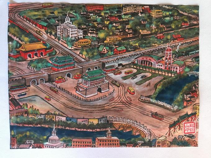
Here is a thing we must pay special attention to, that is, the determination of the central axis of the city which was of the first importance in the plane designing of the city of Dadu. This central axis went along the east bank of the Water Storing Pond And the centre of the emperor’s palace was fixed on the central axis of the whole city and it occupied the most important position the apex of the central axis was at the northeastern bank of the Water Storing pond. This point was taken as the geometric centre of the plane designing of the whole city. Here at this very point was erected a designating building which was called”the Central Pavilion”. On the right side of the pavilion was set up a stone tablet on which were inscribed four Chinese characters,meaning “the Central Platform”. This shows that when the planning and designing of the whole of the new city were made, a precise plane survey was also madeTo the west of the Central Platform was put up the”Drum Tower”And to the north of the drum tower was built the bell tower the drum and the bell were instruments to give the standard time in old days. So the two towers became centres telling the time for the whole city. The fact was also clearly recorded in Marco Polos Travelling Notes.
Once the geometric centre of the whole city was determined, the position of the outer walls of the city was also decided. The construction of the city was basically carried out according to the original planning. Only the east wall slightly drew in for the purpose of avoiding some topographical disadvantages The east west and south walls of the city had three gates each its north had only two gates. Inside each gate there was a straight main road. These roads in the city formed a criss-cross network of communications which resembled a chessboard The middle gate of the south wall was fixed on the central axis of the whole city. The gate was on the central trunk line, which led northward to the emperor’s palace Inside the emperor’s palace, only the main halls which were symbolic of the imperial power, were arranged on the central axis, while those less important buildings were symmetrically arranged on either side of the central axis Outside the imperial city were arranged many horizontal streets and lanes parallel with each other in between meeting these vertical main roads at right angles. These districts were chiefly living quarters of the local inhabitants. These areas were dotted with many central and local government offices and institutions, temples, warehouses and other public buildings. Only two groups of important buildings were laid out in a planned way. The first group of edifices was positioned inside the south gate of the east wall of the big city. This group of edifices was called the Imperial Ancestral Temple a place where the emperors offered sacrifices to their ancestors the other group of buildings was situated inside the south gate of the west wall of the big city It was called the Altar of Land and grain, a place where the emperors offered sacrifices to the god of land and the god of grain.
This plane arrangement of the city of dadu was similar to a kind of ideal designing of imperial capitals in the ancient time. This ideal designing was first seen in a book entitled”A Study of Engineering”which came out in the fifth century B.C. this book exclusively dealt with engineering and also referred to the designing of imperial capitals. According to A Study of Engineering, the imperial city walls in the four directions must form a square. The wall on each side had three gates. Inside each gate there were three main roads parallel to each other so the main roads and streets in the city formed a criss-cross network of communications the imperial city was supposed to face the south. In front of the central point of the imperial city(in the south direction) were located the imperial courts. At the back of the imperial city(in the north direction) were concentrated the market-places. To the left of the imperiacourts (in the east direction) was located the Imperial Ancestral Temple To the right of the imperial city(in the west direction) was situated the altar of land and grain. It is clear that the planning of Dadu City was made on the basis of this ancient ideal designing and also in the light of the specific conditions of the distribution of lakes and waterways on the spot. This plane arrangement was aimed at placing the imperial palaces on the most important position of the whole city. This designing embodied the absolute power of feudal emperors.
