Xinjiang lake
6 min readIn Xinjiang, there are numerous lakes and rivers scattering in mountains, highlands, basins and deserts. In Xinjiang, there are 139 natural lakes over lkm² large, 30 lakes over 10km² large and 11 lakes over 100m² large: the overall area of lakes is up to 10,000km² ranking number 4 in China, only next to Tibet, Qinghai and Jiangsu.
The lakes in Xin jiang are mostly estuarine lakes with highly variable area, and some with frequently changeable location, Since nearly half a century, people have channeled much water for irrigation from upstream river, resulting in decrease in water recharge of lakes year by year, shrinkage of lakes and even dying up Lop Nor and Manas Lake have already drained away, and Aydingkol Lake is close to dying up. At present, there are over 100 lakes in Xin jiang which are relatively stable. Besides, in Xinjiang there are 533 reservoirs of large. medium and small size belong to artificial lakes which have certain value for tourists.
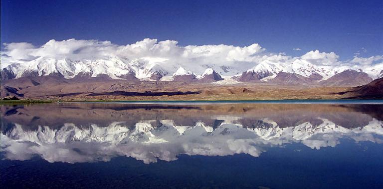
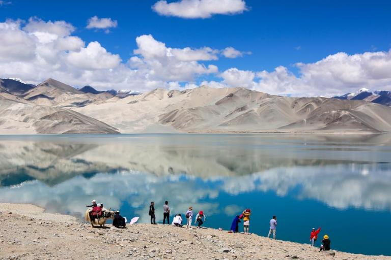
The surfaces of lakes in Xin jiang are spreading in different altitudes. according to the distribution of the landform of the general mountain ranges the mountain lakes can be divided into 4 blocks, including the Altai Mountains, Tianshan Mountains, Pamir and the Kunlun Mountains systems. These mountain ranges rise above the snow line which receive abundant precipitation and form numerous huge centers of glacier, making these mountain ranges”wet islands”,”green islands”in the arid region, while the faulting activities in the mountain ranges encourage formation of intermountain fault depressions or basins, where the snow -melted water gathers with the debris of glacier mud avalanche rockslide and landslide and other deposits damming together, they created advantageous conditions for mountain lakes. Those most famous lakes are often closely associated with the “landmark like”peaks of those famous mountain ranges. For example, Kanas lake and Akkol lake(White Lake) on the south slope of the main peak of the Altai Mountains; Tianchi Lake on the north slope of the highest peak of east Tianshan Mountains Bogda peak: Karakul lake. on the northwest slope of the highest of the east part of Pamir, Muztagata Peak, and others On the other hand there are also extremely low lake surfaces existing. For example, the surface of Ebinur Lake is only 189m above sea level; and aydingkol lake in turpan, 154.31m below sea level, which becomes the lowest point in the land of China.
The lakes in Xin jiang are beautiful, like blocks of jade mirror, inlaid in the deep deserts and high mountains, among which Bosten Lake, Ulungur Lake, Sayram Lake, Ebinur Lake and aydingkol lake are best known.
Bosten lake. the largest freshwater lake in the inland of china. is 980km² with a water storage capacity of 8 billion m³.
The lake surface is broad and is covered with mist, and grows ridden reed and lotus in full bloom, presenting the riverside sceneries in the south part of China, which is renowned as”Pearl of the West Frontier”. Because of the development of the emerging water entertainment of tourism, Bosten Lake is honored as Hawaii”in Xinjiang.
Ulungur Lake, located in Fuhai County, Xinjiang, is one of the 10 greatest lakes in China as well as the largest inland lake in the Northern Xinjiang area, renowned as”Pearl of Junggar”. In summer, Ulungur Lake has sceneries like the sea: covered mist, soft beach andmoderate-temperature water, suitable for fishing and entertainment, actually are excellent sceneries of “bathing beach”The charm of ulungur lake also includes fuhai fish known all over the world.
Sayram Lake, located in Bole City, Xinjiang, meaning”a lake on mountain ridge”in Mongolian, is a high mountain lake always known as”Sai Jiangnan(more beautiful than the sceneries in the south part of the Yangtze River)”. There was a scholar using the following several lines to describe its beauty, The green and the blue are divided separately in the deep and shallow layer; the lake water is as calm as a mirror; the sceneries in the sky reflect in the lake: you can not describe how beautiful the scene is.
Bayanbulak Swan Lake is located in He jing County, Bayingolin Mongol Autonomous Prefecture, Xinjiang. “Bayanbulak”is Mongolian, meaning”abundant mountain spring Bayanbulak Swan Lake, 30km long, about 10m wide and with a total area of over 1, 370km² is the largest place in China for swans to breed and inhabit.
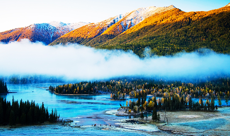
Kanas Lake is the deepest lake in the inland of China with the maximum depth of 188.5m, Kanas Lake is surrounded by ridges and peaks and covered with green vegetation; the lake surface ripples with green waves and the shadow of mountains inverts and reflects on the lake surface. The most amazing miracle is that the color of the lake surface changes along with seasons and weather, into azure blue, azure green, greyish white, or dark green.
The lakes in Xin jiang are beautiful for various colors and special features In addition to the lakes mentioned above there are also other lakes, including charming big and small Dragon pools in Kuga, Karakul Lake with mountain and water sceneries under muztagata Peak, Liyu Lake known as”Lake of Yin and Yang”in Ruoqiang County, Chaiwopu Lake in the southeast of Urumqi and Qinggeda Lake in Wujiaqu City and so on.
In Xinjiang, there are not only all kinds of lakes with fantastic sceneries, but also inland rivers with distinguished features In Xinjiang, there are over 570 rivers of big and small size, as well as 270 mineral springs Most of the over 570 rivers are small independent rivers with a flow path of tens of kilometers and water volume not exceeding 100 million m There are altogether 18 rivers with annual net flow over 1 billion m The longest river is Tarim River with a flow path of 2, 179km, which is also the longest inland river in China. The ma jor international rivers are Irtysh river. Ili River and aksu river. other rivers with comparatively large flow volume are Ulungur River, Kaidu River, Manas River and PeacockRiver and so on. These rivers spread far, and both sides of them are covered with greenshade, displaying a countryside style of oasis and special features. The overall annual surface runoff is 88. 4 billion m, including 43. 1% precipitation flow, 15.9% glacier melt water and 41. 0% groundwater recharge in mountainous area.
Among the rivers of Xinjiang, only Irtysh River flows across the border and finally into the Arctic Ocean, and the others are all inland rivers. They originate from mountainous area, flow downwards to form multiple branches with abundant flows as well as plentiful water and magnificent views When they flow out of the mountain passing and across the alluvial-proluvial fan in front of the mountains, the river water infiltrates rapidly and turns into ground water; the surface river water are channeled for irrigation in large quantities, thus the water volume continues to decrease, either becoming tricklets flowing slowly or disappearing in the great desert, therefore becoming the seasonal streams Ili River, the river with the largest water volume in Xinjiang, is altogether over 1,500kmlong, flowing from Kazakhstan into lli District and then wind into Kazakhstan with the flow path in China territory up to 422km, accounting for around 1/5 of the river flow in Xin jiang, with 3/4 of the water volume flowing out of the border. Irtysh River, the only river in China flowing into the Arctic Ocean, is altogether 546km long in China, covering a watershed of 57000km² with broad river valleys and great flow volume, and is the second largest river in Xin jiang in terms of water volume, with an annual net flow of 11.9 billion m³ .Tarim River the longest inland river in China, is altogether 2,179km long, the fifth largest river all over the world, Tarim means”Unbridled horse”or”farmland””farming in the Uygur language Tarim River winds along the north rim of the Taklimakan Desert, with frequent changes in sedimentation and river diversion In the midstream area. the river course winds with thriving Euphrates poplars standing in each side and shading the sun. What a wonderful sight of the frontier! Ulungur River, the largest inland river in Junggar Basin, also features thick woods in the valleys and magnificent sceneries.