Topography Characteristics of Xinjiang
2 min readTopography Characteristics
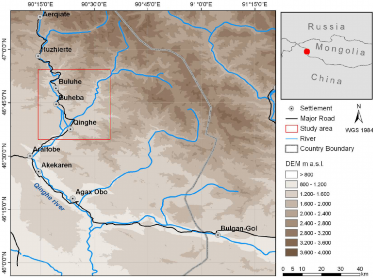
Xin jiang is located in the center of Eurasia, which is far from the sea, and diverse in terrain, and the topography contour can be refered as”Three Mountains Holding Two Basins”, with Altay Mountains in the north, Kunlun Mountains in the south, and TianshanMountains traversing the middle, dividing Xinjiang into north and south parts. There isTarim basin in the south covering an area of 530000km² “and Taklimakan desert is located in the middle of the basin. covering an area of 324000km² which is the largest in China andthe second largest in the whole world respectively: Tarim River of crossing the Tarim Basin is about 2.100 km long. which is the longest inland river in China In the north there is the Junggar Basin, covering an area of 380, 000km² “, and Gurbantunggut Desert located in themiddle of the basin. covering an area of 48000km² “which is the second largest desert in China; in the east, the lowest point of Ayding Lake in Turpan Basin is 154m below the sea level, which is the place of the lowest elevation in inland China, and also the world’s second largest depression; in the west, there is the Yili Basin famed as The beautiful Jiangnan Region beyond the great Wall”customarily, the region in the south of the Tianshan Mountains is called”Nanjiang”(Southern Xinjiang), while the one on the north of Tiansh Mountains is called”Beijiang”(Northern Xinjiang), and the vicinity of Hami and Turpan Basin is called”Dongjiang”(Eastern Xinjiang).
The water area of Xinjiang is about 5, 500km², of which Bosten Lake has a water area of about 980km² making it the largest inland freshwater lake in China a number of oases scatter at the edge of basins and on rivers. covering a total area of about 4.2% of the entire Xin jiang.
There are more than 570 rivers and streams formed by melt water from the laciers and snow mountains within Xin jiang, with an average annual runoff amount of 87.9 billion m³ of surface water for years; the allowable withdrawal of groundwater in plain area is 15. 3 billion m³ ; glacier reserve is 2, 13 trillion m³, accounting for 50% of the whole country which is called the”solid reservoir”. The land resources of Xin jiang is abundant, with the area of lands that can be directly used for agriculture, forestry, and animal husbandry of about one billion mu, accounting for more than one-tenth of the land area suitable for agriculture, forestry and animal hus bandry in China. The existing cultivated land is more than 76 million mu, with the per capita arable land of 3. 45 mu, which is 2, 6 times of thenational average amount; the area of natural grassland is 720 million mu, accounting for 14 5% of the usable grassland area of the country which is one of the five ma jor pastoral areas in China There is 223 million mu of the reserve cultivated land ranking first of china: and the average annual sunshine hours are about 2. 600-3, 400h, ranking the second of China.