Muztagata Peak, Kongur Tagh, and Kongur Tobe Peak
4 min readMuztagata Peak, Kongur Tagh, and Kongur Tobe Peak stand towering like giant jade pillars in the Pamirs, and become the symbol and the representative mountains as well as the most fascinating landscape of Pamirs
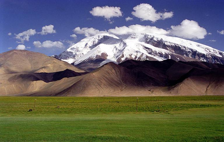
Muztagata peak
Muztagata Peak is located at the junction of Akto County and Taxkorgan Tajik Autonomous County with an altitude of 7, 546m, which is the third highest peak of the Kunlun mountains it is located in the western edge of the tarim basin. and the southeast of the east pamirs with the north latitude38°00′-38°40′ and east longitude744075 40, which is surrounded by tens of glaciers of the average thickness of 300m, and the length of 6-7km, forming a spectacular landscape of glaciers; Therefore, it is called the “Father of Icy mountains.
Muztagata Peak is a round-shaped block mountain with high terrain and cold weather The precipitation is mainly in solid form throughout the year, thus it is beneficial to the development of the glacier. Several large mountain glaciers have developed on both sides of the main peak, distributing in radial pattern; and the ice body with the area of hundreds of square kilometers cover the peak from top of above 7,000m to the height of 5,100m and 5500m, becoming the special overflow glacier of valley type. There are 128 contemporary glaciers within this region with a total area of 377 2lkm and there are 8 glaciers whose areas are over 10km. The largest one is Kirksayi glacier located in the eastern side of the main peak with an area of up to 86. 5km. Thus, this region is one of the important laciations zones of tarim basin.
The climate here is very dry, and the precipitation mainly comes from the interaction of the airflow of upper westerlies with the polar cold wet airflow. The average temperature in the area at an altitude of about 7500m is-20C and the lowest can reach -30%C. the maximum wind is grade 9-ll, and grade 7 in general; The frequent change of the weather is a major feature of this region; even in summer, it may be windy and snowy on the top of the peak with the temperature dropping to -20℃.
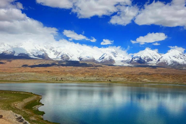
The white snow and the hanging icicles on the top of the Muztagata Peak like the silver beard waving in front of the chest, making the peak look like an old man of longevity with white beard and eyebrows standing out of the mountains, therefore, it has gained the reputation of”Father of Icy Mountains”. At the foot of the mountain, under the blue sky and white cloud, the clear azure Karakul Lake reflects the beautiful images of the towering Muztagata Peak, Kongur Tagh, and Kongur Tobe Peak, as well as the Gobi desert and lush grasslands lying beside, making this region peaceful and mysterious.
Kongur Tagh, and Kongur Tobe peak
Kongur taghis located at 75 3 degrees east longitude and 38 6 degrees northern latitude with an altitude of 7, 649m; and Kongur Tobe Peak is located at 75 1 degrees east longitude and 38. 6 degrees northern latitude with an altitude of 7, 530m. The two peaks are located on the west crest line of the western Kunlun Mountains with a straight-line distance of only 15km, and they are twin-peaks that the mountain bodies are connected, facing the Muztagata Peak in distance. With the snow accumulated all the year round on the peaks, it is especially magnificent which looks like the elaborately carved artwork. The alternative name of Kongur Tagh and Kongur Tobe Peak is”Girls of the Western Paradise”, because that the surrounding snow-capped mountains are like graceful maids of honor and attendants in white.
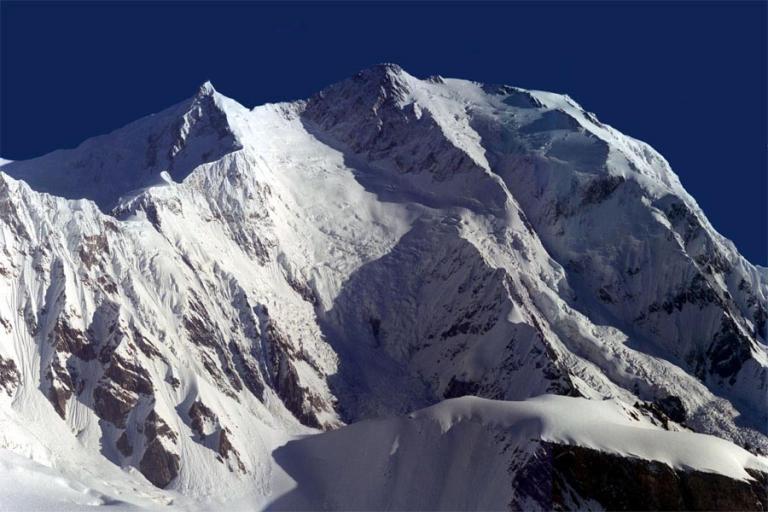
Kongur tobe peak
The snow covers on the Kongur Tobe Peak throughout the year which is like a hat worn by the herdsman, thus the peak is called”Kongur Tobe”by the local herdsmen with the meaning of “white hat”because it is a bit lower than Kongur Tagh. it is also called “The Small Kongur Tagh”, however, the landform of the mountain can sheerly be compared with that of Kongur Tagh. There are steep cliffs of the northern slope, and the complex area ofsnow and ice of the southern slope. The mountains here are steep with an altitude of above 7,000m generally, and the mordern snow line is approximate 5, 900m with large scale of glaciers and well developed glacial landforms. The Carayi Lack Glacier of extending tens o kilometers pours down from the middle of Kongur Tagh and Kongur Tobe peak with the thickness of snow and ice reaching one hundred meters; the snow slops wind the icy peaks in which there are intertwined with crevasses and hidden crevasses: there are also glaciers hanging on the upper part of the mountain with the danger of collapse at any time. For a variety of reasons the snow slides here occur frequently, and the small-scale avalanche can be seen at any time and the massive avalanches occur frequently as well. At the end of May in 1983, an earthquake of magnitude 5. 5 occurred, which caused a rare avalanche withthe fall of 1,000-2,000m, and at that time the earth trembled and the mountains swayed as powerful as a thunderbolt which was extremely spectacular.